Black and Deaf Western Missionaries and Deaf Education in Ghana and Nigeria: The Life and Work of Berta and Andrew Foster - A Global History Case Study (DFG Project, 2022-2025)
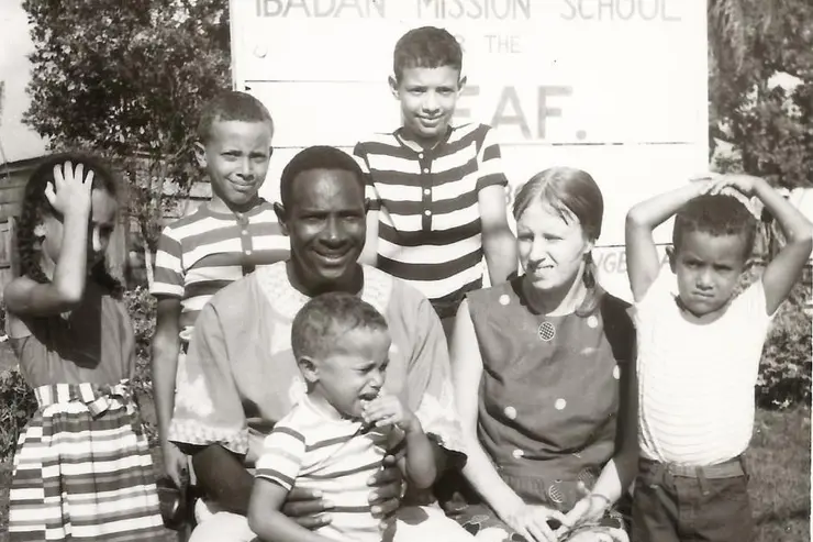
Sometime in 1960, 21-year-old Berta Zuther (1939-2018) from West Berlin informed her family that she had bought a ticket to Accra (Ghana), obtained the necessary visas and vaccinations and would be leaving the next day to set up schools and churches for deaf people in Africa together with the African-American missionary Andrew Jackson Foster (1925-1987). Berta and Andrew were both deaf themselves... more
Picture: © Faith Haynes

Cartographies of Africa and Asia (1800-1945). A digitisation project for the Perthes Collection in Gotha (KarAfAs)
As the estate of the publishing house Justus Perthes, the Perthes Collection contains one of the most important map archives in continental Europe. The map collection is a stroke of luck, as it includes both the maps produced in Gotha and a wide range of maps purchased internationally by the publishing house. Thanks to generous funding from the Federal Ministry of Education and Research, a first central part of the collection is now being digitally catalogued and thus made accessible worldwide... more
Image: Bruno Hassenstein, original map of the North Abyssinian borderlands, scale: 1 : 500,000, 1864 © Perthes Collection / Gotha Research Library, SPK 547-112085962.
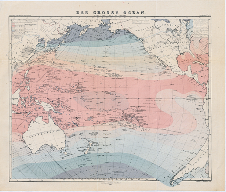
Sea Maps: For a History of Globalization from the Perspective of Water
Maps, especially sea and ocean maps, have so far played a marginal role in the history of globalisation, although they illustrate maritime spaces and the associated global connections like almost no other medium. Therefore, with the help of sea and ocean maps, a hitherto little-known history of the period of upheaval from the middle of the 19th to the middle of the 20th century is to be told, which can open up a new perspective on the genesis of today's global world... more
Image: August Petermann, Der grosse Ocean, Mitteilungen aus Justus Perthes' Geographischer Anstalt, [3] (1857), plate 1 © Gotha Research Library, SPA 4°000100.
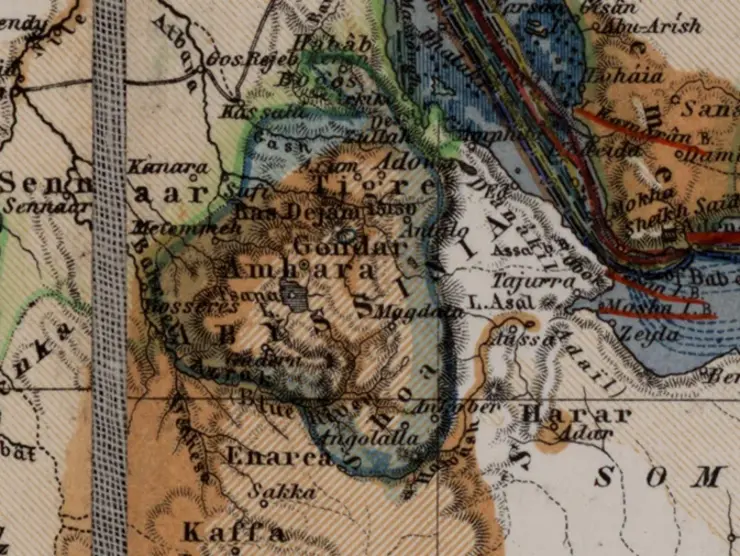
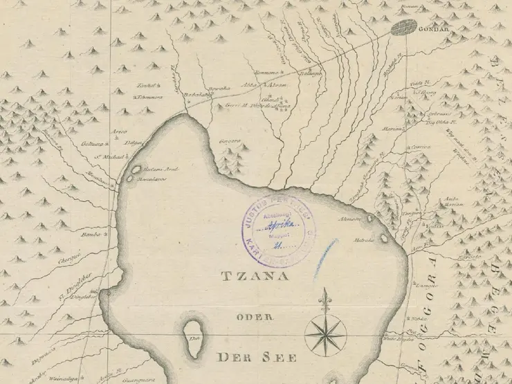
Cartographic Sources and Territorial Transformations in the Horn of Africa since the Late 18th Century (ETHIOMAP)
The research project comprises two partner projects being carried out simultaneously in France (funded by French National Research Agency) and Germany (funded by German Research Foundation). The objective of the research project is to systematically document, classify, and analyse historical maps related to Ethiopia, many of which are largely unknown in Ethiopian research... more
Image: Abyssinia, detail from: Hermann Berghaus, Chart of the World, 6th edition, Gotha: Justus Perthes 1871 © Forschungsbibliothek Gotha der Universität Erfurt.
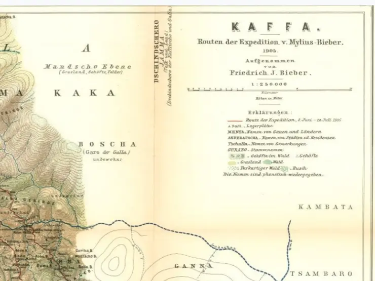
From Kingdom to Tributary Province: Society, Ecology and Politics - An Ethnohistorical Study of Kafa (present-day Southwest Ethiopia), c. 1600-1900
This dissertation reconstructs the historical development of Kafa, with focus on ecocultural knowledge, from its establishment as a hierarchical state in the Horn of Africa to its incorporation into the Ethiopian Empire. The Kingdom of Kafa was a historical independent political entity located in the southwestern highlands of present-day Ethiopia. It is a region known for its remarkable biodiversity and diverse ecosystems characterised by an impenetrable forest landscape. Over centuries Kafa had developed into a sovereign entity with its own socio-cultural and political institutions reflecting its internal developments... see more
Image: Detail of Julius Friedrich Bieber, Kaffa. Routes of the Mylius expedition-Bieber, 1905, in: Dr A. Petermann's Mitteilungen aus Justus Perthes' Geographischer Anstalt 54 (1908), plate 10.
Historical Sources, Oral Traditions, and Interpretations on the Period of Ras Sïḥul Mika'el, 1692-1780
The life and career of Ras Sïḥul Mikaʾél and the administrative history of his homeland province, Tigray, is one of the least understood periods in 18th century Ethiopian history. This is because the Ras has lived and ruled since the beginning of the period, which ushered Ethiopia into a long period of provincial and sectarian divisions between different provincial and religious leaders. The problem further gains strength owing to the dearth of materials on the career of the Ras... more
Image: James Bruce, Chart of the sources of the Nile, and the author's double attempt to travel thither, op. cit. 1791, 49 x 27 cm, Gotha Research Library, Gotha Perthes Collection, SPK 40.21 A (02).
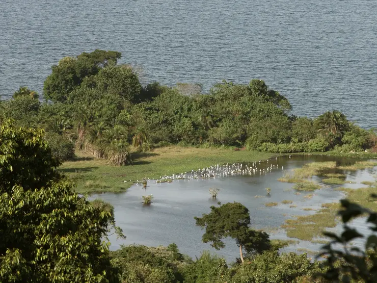
The Rubondo-Experiment. Labor Insularity and Nature Politics in the Decolonization of East Africa
Why did the postcolonial upheaval in East Africa – the "Revolt against the West" (Geoffrey Barraclough) – not also entail a departure from Western concepts of nature and its protection? How did decolonization permeate the handling of the natural environment, and what role did nature policy initiatives play in shaping postcolonial conditions? The history of Rubondo Island, the oldest and largest nature conservation island in Africa, located in the south-western part of Lake Victoria is used to find exemplary answers to these questions... more
Picture: Rubondo Island in March 2015 © Felix Schürmann
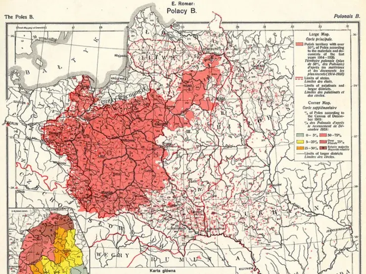
German East, Polish West. Constructing German-Polish Spaces during the First Half of the 20th Century - A History of Knowledge
The study investigates how geographers, cartographers, and ethnologists constructed ostensibly homogeneous spaces and popularized them as political statements. The focus is on the production of knowledge related to thematic maps and ethnographic objects by German and Polish publishers, museums, and institutions... more
Image: Plate XI "Polacy B" from the atlas "Geograficzno-Statystyczny Atlas Polski" by Dr Eugenjusz Romer, published in Lwow in 1921 © Wikimedia Commons, Maproom.
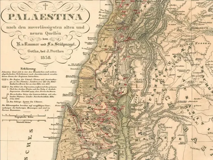
Plants, Maps, Amuletts. Objects of Knowledge in Research on Palestine 1877-1929
The Middle East has been a focal point of colonial projects and theological research since the 19th century. What conceptions regarding environment, space, and cultural history underpinned the creation of scientific collections and maps of the region? Did the prospect of a future German colony or the projection onto a Land of the Bible take center stage in the narrative constructed from the compiled evidence? Furthermore, how did Zionist researchers build upon Christian Palestine research?… more
Image: Karl v. Raumer, Friedrich v. Stülpnagel: Palästina, 3rd ed., Gotha 1853-1862 © Perthes Collection.
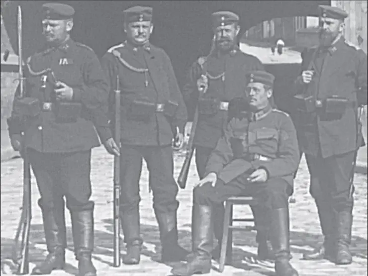
War Maps. German Cartography during World War I
The project investigates the trajectories of German cartography during the course of the First World War, focusing on the aspects of production and consumption. Central inquiries revolve around new production structures, emerging types of maps, and the utilization of maps… more
Image: Field postcard, Hermann Haack (seated in the foreground) as a Landsturm officer, Arlon, tunnel guard on 27 September 1914 © Perthes Collection.

![[Translate to English:] facebook icon](/fileadmin/SocialMediaIcons/iconfinder_06-facebook_white.svg)
![[Translate to English:] instagram icon](/fileadmin/SocialMediaIcons/iconfinder_38-instagram_white.svg)
![[Translate to English:] YouTube icon](/fileadmin/SocialMediaIcons/iconfinder_18-youtube_white.svg)
![[Translate to English:] xing icon](/fileadmin/SocialMediaIcons/iconfinder_xing_white.svg)