Forschungskolleg Transkulturelle Studien / Sammlung Perthes
Schloss Friedenstein – Pagenhaus
Schlossplatz 1
99867 Gotha

Beatriz Véliz Argueta is a Guatemalan interdisciplinary scholar interested in urban and spatial history and the scientific discourses employed in spatially constituting the Central American isthmus in the nineteenth-century. Her work focuses on the construction of place (people and space) in cross-cultural encounters and combines cartography, history of science and art history in making visible the mapping of the Other. As a researcher of cross-cultural encounters, she is passionate about multi-archival and multi-linguistic projects that place Guatemalan history in the context of its interactions with the wider world.
Trained at Universidad del Valle (Guatemala), Jawaharlal Nehru (India), Kwazulu-Natal (South Africa) and Freiburg (Germany) universities, she completed her PhD at Humboldt Universität zu Berlin (magna cum laude) in 2020. She was Research Fellow at the Klassik Stiftung Weimar (KSW), Postdoctoral Researcher at the Forschungskolleg Transkulturelle Studien / Sammlung Perthes, Erfurt University, and Andrew W. Mellon Postdoctoral Fellow at Penn State University. As Visiting Fellow at Goldsmiths, University of London, she co-founded the international Urban Photography Summer School (iUPPS).
Her work has been supported by the Deutsche Forschungsgemeinschaft (DFG), the Andrew W. Mellon Foundation and Fundación Carolina, among others.
PhD, Humboldt Universität zu Berlin
MA Global Studies, Albert-Ludwigs-Universität Freiburg (Germany), University of Kwazulu-Natal (South Africa) and Jawaharlal Nehru University (India)
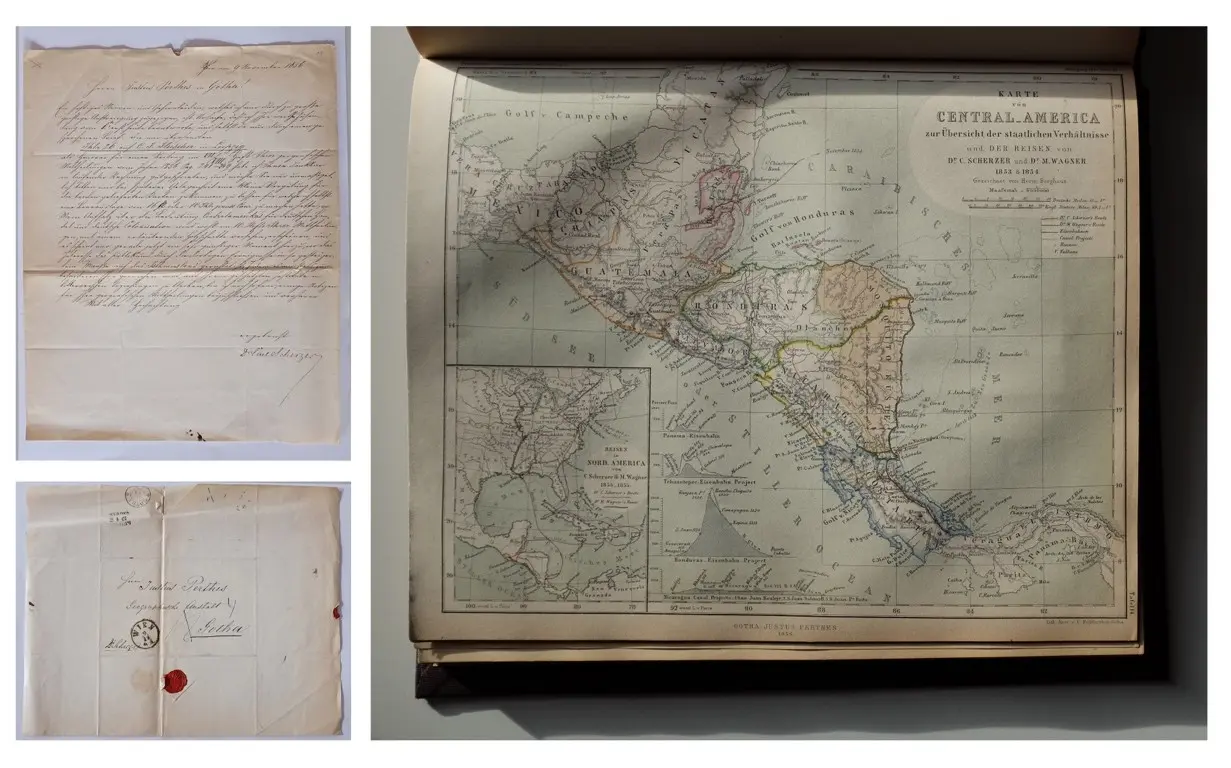
Bifurcated cartographies is a multiarchival research project that seeks to make visible the scientific discourses employed in spatially constituting the Central American isthmus in the nineteenth century from a cross-continental perspective. Following independence from Spain (1821) the isthmus was intensely explored and mapped by different actors – diplomats, scientists, and lay people – attempting to draw the borders of this fragmented territory and place its inhabitants within a larger historical narrative. These set of subtly divergent cartographies were central in the co-construction of Central American territorial claims and in shaping its emerging sense of national identity.
Images: Right: Map of Central America (1856) Mittheilungen Aus Justus Perthes‘ Geographischer Anstalt Über Wichtige Neue Erforschungen Auf Dem Gesammtgebiete Der Geographie. Perthes Verlag. Left: Letter exchange of the exploration undertaken for the scientific publication. Source: Perthes Collection.
2023
Sawyer Seminar Podcast. Told through vivid historical accounts each episode explores the themes of “Transmission, Containment and Transformation” in early modern cities – from Florence to colonial Mexico via New Delhi. Each podcast makes visible little-known singular stories that enrich our understanding of the human experience.
https://earlymoderncities.podbean.com/
2022
“Mapping the Other: the cartographer as a spatio/ temporal translator in early nineteenth century German cartography”. The International Society for the History of the Map, 12 – 13 May 2022, Montevideo.
“Moralizing the landscape: On runaways, pajuides and the appearance of freedom in eighteenth century Guatemala”, Sawyer Seminar Series on “Places of Confinement and Evasion”, 25 March, 2022, Penn State University, Pennsylvania
2017
“On Postcolonial practices and Decolonizing strategies. An introduction to A Global Dialogue” A Global Dialogue on the Everyday Production of the Postcolonial World and its Others, 10 – 12 May 2017, Humboldt Universität zu Berlin, Berlin.
Mapping the Self and the Other in time and space: On Bertuch, the Landes-Industrie-Comptoir, and Weimar’s scientific and artistic communities and the structuring of the world (forthcoming)
Mapping the Other: On textual and spatial translation and the making of a great German Atlas (forthcoming)
Entangled Urban Narratives: The making of informal colonial and postcolonial Guatemala City (forthcoming)

![[Translate to English:] facebook icon](/fileadmin/SocialMediaIcons/iconfinder_06-facebook_white.svg)
![[Translate to English:] instagram icon](/fileadmin/SocialMediaIcons/iconfinder_38-instagram_white.svg)
![[Translate to English:] YouTube icon](/fileadmin/SocialMediaIcons/iconfinder_18-youtube_white.svg)
![[Translate to English:] xing icon](/fileadmin/SocialMediaIcons/iconfinder_xing_white.svg)
University of Erfurt (Campus)
Nordhäuser Str. 63
99089 Erfurt