Associate (Max Weber Centre for Advanced Cultural and Social Studies)
Office hours
nach Vereinbarung
Visiting address
Max Weber Centre for Advanced Cultural and Social Studies
C19 – research building "Weltbeziehungen"
Max-Weber-Allee 3
99089 Erfurt
Mailing address
Universität Erfurt
Max Weber Centre for Advanced Cultural and Social Studies
Postfach 90 02 21
99105 Erfurt

Personal information
Short biography
Dr. Ribar Khalaf is an archaeologist specialising in the archaeology of the ancient Near East. He received his PhD in archaeology from Cairo University in 2018; his research examined the cultural and architectural history of northern Mesopotamia.
He has extensive experience of excavation and archaeological survey work across Syria, and has worked as a lecturer and researcher at the University of Rojava, contributing to the development of academic programmes in history, archaeology and cultural heritage.
His current research focuses on integrating archaeological analysis with digital methods, particularly GIS and remote sensing. He has developed an interactive digital map documenting destroyed and endangered archaeological sites in north-eastern Syria, and has published several peer-reviewed articles on the region's cultural and architectural history.
He is particularly concerned with protecting cultural heritage in conflict zones, combining scientific analysis, digital tools and collaboration with local communities to develop practical, sustainable strategies.
Interactive WebGIS platform: https://zerstorte-staetten-nordostsy-dr-ribar.netlify.app/
Research project
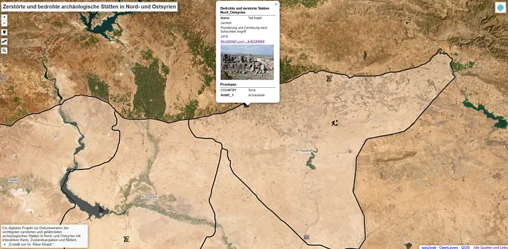
This project examines the impact of the Syrian conflict on the archaeological landscape of the Jazira region, developing a forward-looking model for heritage protection and management. Rather than focusing solely on damage documentation, the project aims to identify ongoing and future risks to archaeological sites.
Using satellite imagery, geographic information system (GIS)-based spatial analysis and qualitative data sourced locally, the project detects patterns of damage and risk, including urban expansion, agricultural activity, looting and environmental pressures.
These data are integrated into a digital risk assessment model and an interactive, web-based platform that enables visualisation and analysis. A key aspect of the project is its participatory approach, incorporating the knowledge and involvement of local communities and institutions.
The project will produce a comprehensive risk map, a digital early warning system and practical guidelines for site protection and management. By combining archaeological expertise with digital methods, the project offers a transferable model for protecting cultural heritage in conflict-affected regions beyond Syria.

![[Translate to English:] facebook icon](/fileadmin/SocialMediaIcons/iconfinder_06-facebook_white.svg)
![[Translate to English:] instagram icon](/fileadmin/SocialMediaIcons/iconfinder_38-instagram_white.svg)
![[Translate to English:] YouTube icon](/fileadmin/SocialMediaIcons/iconfinder_18-youtube_white.svg)
![[Translate to English:] xing icon](/fileadmin/SocialMediaIcons/iconfinder_xing_white.svg)