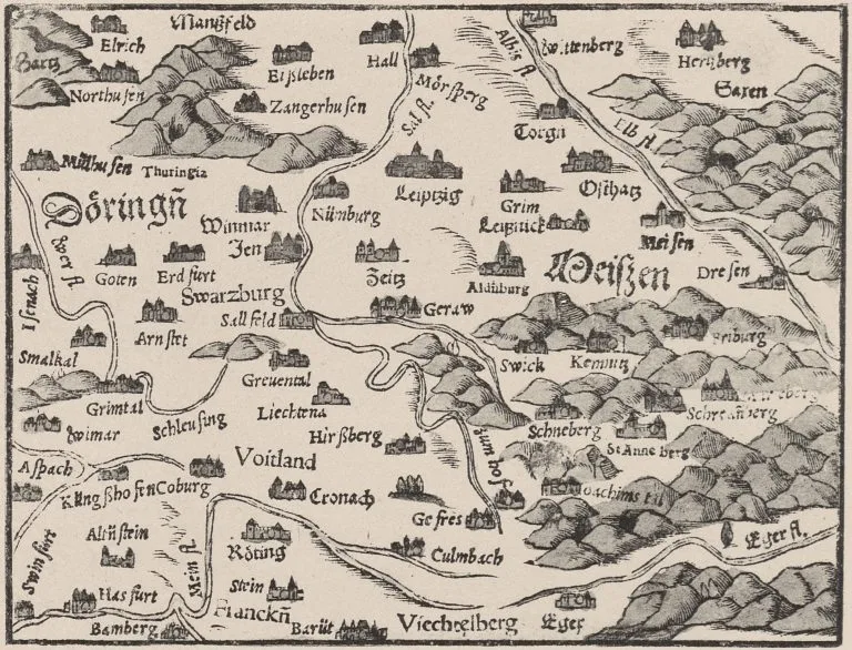
In contrast to other regions and landscapes of the empire, the first regional maps for Thuringia appeared comparatively late, only in the middle of the 16th century. Then, however, the cartographic visualization of the area between the Werra and Saale rivers, the Harz Mountains and the Thuringian Forest quickly gained momentum. Johannes Mellinger and Adolar Erich created exceptional certificates of the cartography of Thuringia, which were distributed throughout Germany and Europe by the atlases of Abraham Ortelius and Gerhard Mercator, and later by the atlases of the publishing families Blaeu and Homann. The maps not only document the development towards an increasingly exact cartography of Thuringia, they also provide historically valuable information on the economic and settlement history of Thuringia. They are at the same time documents of a virulent Thuringian national and self-awareness, whose roots reach far down into the Middle Ages.
Due to limited capacity, registration for the event is requested by March 13 at e-mail: sammlungperthes.fb@uni-erfurt.de.


![[Translate to English:] facebook icon](/fileadmin/SocialMediaIcons/iconfinder_06-facebook_white.svg)
![[Translate to English:] instagram icon](/fileadmin/SocialMediaIcons/iconfinder_38-instagram_white.svg)
![[Translate to English:] YouTube icon](/fileadmin/SocialMediaIcons/iconfinder_18-youtube_white.svg)
![[Translate to English:] xing icon](/fileadmin/SocialMediaIcons/iconfinder_xing_white.svg)